
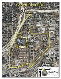
District Total Acreage: 143
CRA Termination Date: 2036
That part of Section 13, Township 29 South, Range 18 East, AND Section 18, Township 29 South, Range 19 East, all lying within the City of Tampa, Hillsborough County, Florida, lying within the following described boundaries to wit:Beginning at the intersection of the Centerline of Interstate Highway 4 (S.R. 400), and the Centerline of Nebraska Avenue (S.R. 45), as shown on State of Florida - State Road Department Interstate Expressway No. 4, Section No. 10190-2412-41-14 of State Road No. 400, Hillsborough County, State of Florida State Road Department Right of Way Map; run thence Southerly along said Centerline of Nebraska Avenue (S.R. 45), to its intersection with the Centerline of 7th Avenue; thence Easterly along said Centerline of 7th Avenue, to its intersection with the Centerline of Nick Nuccio Parkway; thence Southerly along said Centerline of Nick Nuccio Parkway, and its Southerly projection, to its intersection with the Westerly projection of the Centerline of 3rd Avenue (Alabama Avenue) and the Southerly boundary of MARYLAND AVENUE SUBDIVISION, a subdivision as recorded in Plat Book 41, Page 71 of the public records of Hillsborough County, Florida; thence Southwesterly along said Southerly boundary of MARYLAND AVENUE SUBDIVISION, and its Southwesterly projection, to its intersection with the Westerly boundary of said Section 18, Township 29 South, Range 19 East, said Westerly boundary lying in Nebraska Avenue; thence Northerly along said Westerly boundary of said Section 18, to its intersection with the Easterly projection of the Southernmost boundary of the Housing Authority of the City of Tampa, Florida Central Avenue Project, said boundary as established per City of Tampa Ordinance No. 1518-A; thence Westerly along said projection and boundary , and Southerly and Westerly along said Southernmost boundary of said Housing Project, and its Westerly projection, to its intersection with the Centerline of the Orange Street (Orange Avenue) and Jefferson Street Connector, as shown on Right of Way Map, titled - Downtown Interstate Connector to Pierce and Jefferson Streets, File No. I-6-12, prepared by Reynolds, Smith & Hills, for the City of Tampa, Department of Public Works ; thence Northerly along said Centerline of Orange Street and its Northerly projection to and along the Centerline of East Bay Street, as shown on PLAN OF MOBLEY'S SUBDIVISION, a subdivision of record as recorded in Deed Book "Q", Page 539 of the public records of Hillsborough County, Florida, to its intersection with the Centerline of Interstate Highway 275 (S.R. 93), as shown on the Tampa Expressway System Downtown Distributor, Section No. 10190-2412-41-14 of State Road No. 400, Hillsborough County, State of Florida State Road Department Right of Way Map; thence Northeasterly along said centerline of Interstate 275 (S.R. 93), to its intersection with the Centerline of Interstate Highway 4 (S.R. 400); thence Easterly along said Centerline of Interstate Highway 4 (S.R. 400), to its intersection with the Centerline of Nebraska Avenue (S.R. 45), said intersection being the Point of Beginning.
LESS that part of Section 13, Township 29 South, Range 18 East, Hillsborough County, Florida being more particularly described as follows:
All of Blocks 1, 2, 5 and 6 of MIDDLETOWN, a subdivision of record as map or plat thereof is recorded in Plat Book 2, Page 28, of the public records of Hillsborough County, Florida AND all of the vacated alleys lying within said Blocks AND that portion of vacated Estelle Street, Governor Street and 3rd Avenue abutting said blocks AND the East 1/2 of vacated Lamar Street abutting said Block 2.
AND LESS:
Lots 1 and 2, Block 2, GIDDENS SUBDIVISION, as recorded in Deed Book "K", Page 518, of the public records of Hillsborough County, Florida AND all of that vacated portion of Governor Street abutting said Block 2, LESS the West 29.10 feet of the East 50.50 feet of the South 79.00 feet of said Lot 1, Block 2.
AND LESS:
Lots 1 thru 4 and 10 thru 14, Block 4, MAP OF OAK RIDGE, a subdivision of record as map or plat thereof is recorded in Plat Book 1, Page 76, of the public records of Hillsborough County, Florida AND Lots 5 and 9, Block 4 of said MAP OF OAK RIDGE, AND the vacated alley abutting said lots in Block 4 AND all of that vacated portion of Henderson Avenue abutting said Block 4, LESS that part of said lots 5 and 9 acquired as right of way for Interstate 275.
AND LESS:
Blocks 2 and 3, STOCKON COURT, a subdivision of record as map or plat thereof is recorded in Plat Book 1, Page 29, of the public records of Hillsborough County, Florida AND that portion of vacated Estelle Street, Mitchell Street and 3rd Avenue abutting said blocks AND that portion of vacated Mitchell Street and 3rd Street abutting Lot 1, Block 2, LIPSCOMB VILLA REVISED MAP, a subdivision of record as map or plat thereof is recorded in Plat Book 2, Page 52, of the public records of Hillsborough County, Florida.
AND LESS:
Lots 7 thru 12, Block 4, STOCKON COURT, a subdivision of record as map or plat thereof is recorded in Plat Book 1, Page 29, of the public records of Hillsborough County, Florida AND the vacated alley abutting said lots in Block 4.
AND LESS:
Lots 9 and 10, Block 1, STOCKON COURT, a subdivision of record as map or plat thereof is recorded in Plat Book 1, Page 29, of the public records of Hillsborough County, Florida AND the vacated alley abutting said lots in Block 1 AND all of that portion of vacated Estelle Street abutting said Lot 10, Block 1.
AND LESS:
Lot 8, Block 1, STOCKON COURT, a subdivision of record as map or plat thereof is recorded in Plat Book 1, Page 29, of the public records of Hillsborough County, Florida, AND the vacated alley abutting said lot 8, Less the East 1/2 of said Lot 8, and Less the West 1/2 of the North 64 1/2 feet of said Lot 8.