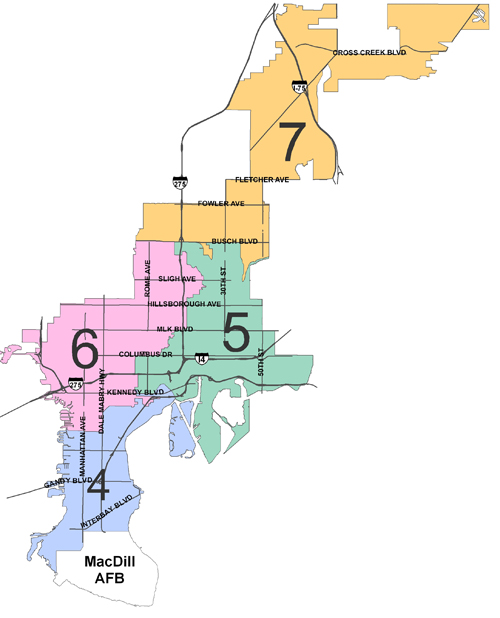
A single-member district, running North from San Jose Street to Waters Avenue on the North, including Drew Park, Beach Park and the Westshore Business District.
The district is bordered on the West by Old Tampa Bay, the Courtney Campbell Causeway, Rocky Point Golf Course, Tampa International Airport and the City Limit line, up to Hillsborough Avenue. The district then continues East following the City Limit Line along Hillsborough Avenue and Henry Avenue. The district then continues North following the City Limit Line along Armenia Avenue to Waters Avenue. The district then continues East along Waters Avenue to Huntley Avenue. The district then meanders North along Huntley Avenue, East along Wood Street, South along Mitchell Avenue, East along Fairbanks Street, South along Nebraska Avenue, East along the Hillsborough River, South across the River, Northeast along Park Circle, South along 18th Street, West along Sligh Avenue, South along 17th Street, East along Knollwood Street, South along Escort Avenue, East along Diana Street, South along 19th Street, West and South along Lambright Street N., East along Lambright Street S., South along 17th Street, West along North Street, South along 15th Street, West along Paris Street, South along 12th Street, West along Clifton Street, Southwest and North along Roberta Circle, West along Clifton Street, South along Nebraska Avenue, West along Ida Street, South along Taliaferro Avenue, West along Dr. Martin Luther King, Jr. Blvd., South along Florida Avenue, West along Virginia Avenue, South along Tampa Street, East along Kentucky Avenue, South along Florida, West along Indiana Avenue, South along Arlington Avenue, West along Ohio Avenue, North along Highland Avenue, West along Indiana Avenue, South along Dartmouth Avenue, West along Woodlawn Avenue, South along Ola Avenue, East along Plymouth Street, South along Highland Avenue, West along Adalee Street, South along Ola Avenue, West along Alfred Street, South along Massachusetts Avenue, West along West Street, South along Boulevard, West along Warren Avenue, South along Esther Street, West along Euclid Avenue, South along Munro Street, West along Columbus Drive, South along Armenia Avenue, East along Interstate 275, South along Howard Avenue, West along Gray Street, South along Armenia Avenue, East along North "A" street, South along Moody Avenue, East along Cleveland Street, South along Boulevard, West along Platt Street, South along Willow Avenue, West along Horatio Street, South along Oregon Avenue, West along De Leon Street, South along Dakota Avenue, West along Swann Avenue, North along Fremont Avenue, West along De Leon Street, North along Melville Avenue, West along Platt Street, South along Armenia Avenue, East along Horatio Street, South along Howard Avenue, West along De Leon Street, South along Armenia Avenue, Southwest along Parkland Blvd., West along Fountain Blvd., North along Audubon Avenue, West along Swann Avenue, Southwest along Henderson Blvd., South along Dale Mabry Highway, West along Palmira Avenue, North along Manhattan Avenue, then West along San Jose Street finishing the district boundary.
Neighborhood Associations in District 6: Armenia Gardens Estates, Beach Park, Beach Park Isles, Bon Air, Carver City/Lincoln Gardens, Culbreath Bayou, Culbreath Heights, Culbreath Isles, Drew Park, Gray Gables, Lowry Park, Marina Club, MacFarlane Park, Mid-Peninsula, Midtown, North Bon Air, North Hyde Park, Northeast MacFarlane Park, Oakford Park, Palma Ceia West, Parkview, Plaza Terrace, Ridgewood River, Riverbend, Riverside Heights, South Seminole Heights, Wellswood, West Tampa, Westshore Palms and sections of Lowry Park North, Southeast Seminole Heights, Sunset Park and Tampa Heights.
For More Information on Neighborhood Associations in this District visit the Neighborhood Engagement web site or contact them at 813-274-7574